
Inovation
"Innovative Drone Technology: The Future of Wildfire Prevention"
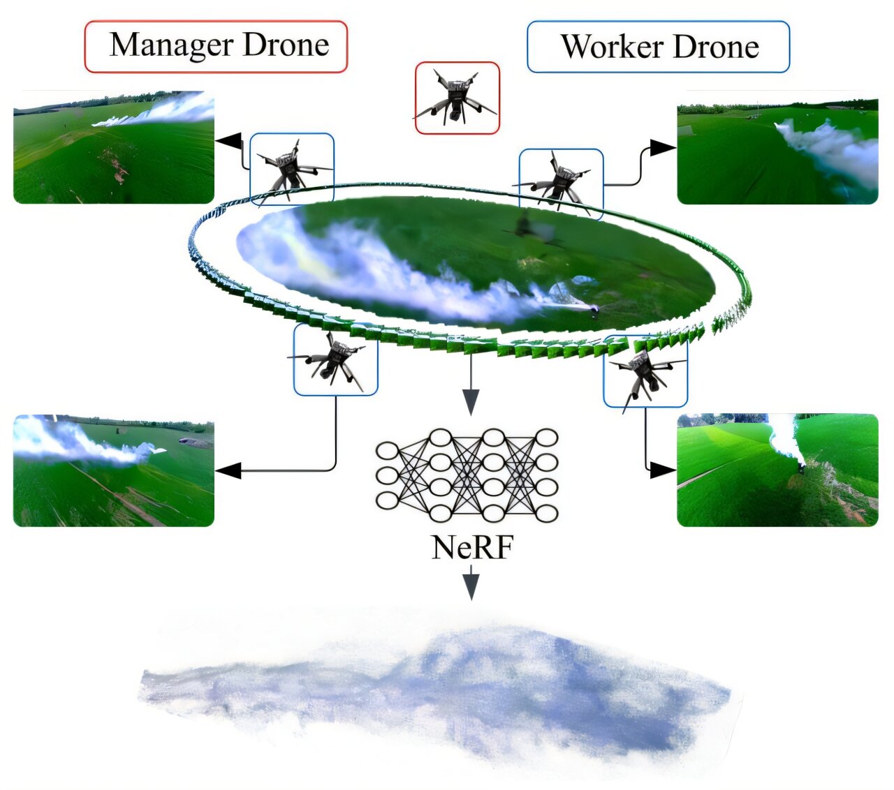
Amidst a 30-acre prairie fire at Cedar Creek Ecosystem Science Reserve, north of the Twin Cities, plumes of smoke rose steadily. Five black drones buzzed around in the haze.
Over 150 feet below the hovering robots, research student Nikil Krishnakumar controlled the drones from the ground. The study has been published on the arXiv preprint server.
“It’s all autonomous now,” he remarked. “I’m not doing anything.”
The mission of the aerial robotic team was to observe the smoke from the prescribed burn and transmit the data to a ground computer. This computer then analyzes the smoke data to comprehend the flow patterns of the fire, as explained by Krishnakumar.
The University of Minnesota project is at the forefront of research using artificial intelligence to identify and track wildfires. This work has become increasingly urgent due to the expected rise in wildfires caused by climate change, similar to the ones that devastated Manitoba this past summer.
NOAA’s Next-Generation Fire System comprises two satellites positioned 22,000 miles above the equator to detect new heat sources and relay this information to local National Weather Service stations and an online dashboard. Earlier this year, the satellites were credited with identifying 19 fires in Oklahoma, preventing approximately $850 million in structure and property damage, according to the agency.
Locally in Minnesota, Xcel has installed tower-mounted, AI-equipped high-definition cameras near power lines in Mankato and Clear Lake, with plans for 36 more installations. When a fire is detected, local fire departments are promptly notified.
On Friday, Krishnakumar and other members of the U’s research team conducted their 11th trial at the U’s field station in East Bethel, showcasing significant improvements from previous attempts.
In earlier field tests, the first-generation drones experienced multiple crashes, Krishnakumar noted. The team enhanced sensors for improved data collection and autonomous steering, enlarged the drones, and outfitted them with superior propellers to enhance propulsion.
“The ultimate goal is for these drones to help understand the behavior and direction of wildfires and to conduct extensive surveillance of wildfires,” Krishnakumar stated. “The primary challenge we’re addressing is determining how far smoke particles can travel and the altitude they can reach.”
Understanding the behavior of particles such as embers can aid firefighters in preventing the spread of wildfires, according to researcher Yue Weng.
While the project has yet to be utilized for large-scale wildfires, the research signifies a significant advancement towards employing fully autonomous drone systems for emergency response and scientific research missions, according to Jiarong Hong, a professor at the University of Minnesota’s Department of Mechanical Engineering.
Minnesota has recorded 1,200 wildfires this year, according to the state Department of Natural Resources. On a smaller scale, this technology could enhance the management of prescribed burns, Hong noted. Between 2012 and 2021, 43 wildfires nationwide were caused by prescribed burns that went out of control, as reported by the Associated Press.
“Characterizing and measuring particle transport in real-world conditions is extremely challenging. Traditionally, people conduct small-scale lab experiments to study this at a fundamental level,” Hong explained. “However, such experiments do not capture the complexity of real-world environments.”
Smoke patterns change with the wind’s direction. Deploying multiple drones—with one central drone managing the others—allows them to navigate the air without human intervention, Hong pointed out.
Custom-built by students, the 11-pound drones are designed to autonomously collect particle data. Future enhancements to the project include gathering more data and extending the drones’ battery life. Currently, the drones can operate in the air for approximately 25 minutes, less in colder temperatures, according to Hong.
“We have drones flying at different altitudes, enabling us to measure particle composition at various elevations simultaneously,” Hong elaborated.
“Particles vary in shape and density, with irregular shapes and varying levels of porosity. Nevertheless, we have successfully characterized their morphology and shape for the first time.”
2025 The Minnesota Star Tribune. Distributed by Tribune Content Agency, LLC
Citation:
Researchers launch smoke-sensing drones that one day could fight wildfires (2025, November 3)
retrieved 10 November 2025
from https://techxplore.com/news/2025-11-drones-day-wildfires.html
This document is subject to copyright. Apart from any fair dealing for the purpose of private study or research, no
part may be reproduced without the written permission. The content is provided for information purposes only.


Maximizing MacBook Battery Life: Tips for Charging Slowly and Setting Charge Limits

Lost Legacy: The Disappearance of AC Schnitzer and the Changing Automotive Landscape

Cyber Warfare: The Battlefront of the Digital Age

Monster Hunter Stories 3: The Challenge of Twisted Reflection

Revolutionizing Cash-Pay Clinic Prescribing: VITL Secures $7.5M Amid GLP-1 Boom

Balancing Act: The Decision to Shut Down Sora

Exclusive Arrival: Cupra Born VZ Lands in Australia – But There’s a Twist!

iPhone 12 Pro Max vs Samsung Note 20 Ultra / Huawei Mate 40 Pro Camera Test Comparison.

ClickFix: The New Threat to macOS Security

EU Takes Action Against Instagram and Facebook for Violating Illegal Content Rules

Warning: Facebook Creators Face Monetization Loss for Stealing and Reposting Videos
Facebook Compliance: ICE-tracking Page Removed After US Government Intervention

Facebook’s New Look: A Blend of Instagram’s Style

Facebook and Instagram to Reduce Personalized Ads for European Users

InstaDub: Meta’s AI Translation Tool for Instagram Videos

Reclaim Your Account: Facebook and Instagram Launch New Hub for Account Recovery

Meta discontinues Messenger apps for Windows and macOS

Breaking Updates: Meta Connect 2025 Unveils Latest Developments
iPhone 12 Pro Max vs Samsung Note 20 Ultra / Huawei Mate 40 Pro Camera Test Comparison.

iPhone 12 Pro Max vs Samsung Note 20 Ultra / Huawei / Xiaomi / OnePlus Battery Life DRAIN Test.

The BEST Smartphone of 2020 🏆

The Self-Healing Smartphones!

Apple is not what it used to be.

Smartphones are Boring now.

The Fastest Android Phone Ever.

Unboxing the $122,000 Smartphone. 🤯

Are Linux Smartphones about to KILL Android?
-
 Facebook5 months ago
EU Takes Action Against Instagram and Facebook for Violating Illegal Content Rules
-
 Facebook5 months ago
Warning: Facebook Creators Face Monetization Loss for Stealing and Reposting Videos
-

 Facebook6 months ago
Facebook Compliance: ICE-tracking Page Removed After US Government Intervention
-
 Facebook4 months ago
Facebook’s New Look: A Blend of Instagram’s Style
-
 Facebook4 months ago
Facebook and Instagram to Reduce Personalized Ads for European Users
-
 Facebook6 months ago
InstaDub: Meta’s AI Translation Tool for Instagram Videos
-
 Facebook4 months ago
Reclaim Your Account: Facebook and Instagram Launch New Hub for Account Recovery
-
 Apple5 months ago
Meta discontinues Messenger apps for Windows and macOS